Civil-use observation satellite sends back 1st detailed images
Photos expected to play important role in land surveying, urban planning and statistics


China's best optical Earth observation satellite for civil use has started operations and has sent back more than 14,000 images, according to the China National Space Administration.
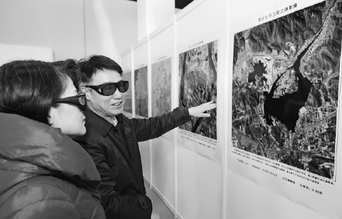
The administration published 22 high-resolution images taken by the Gaofen 7 of Beijing Capital International Airport, the newly built Beijing Daxing International Airport, some regions in Anhui, Guangdong and Shandong provinces as well as some foreign locales. Airplanes, vehicles, buildings and trees can be clearly seen in the images.
With a design life of eight years, the 2.7-metric ton satellite was launched atop a Long March 4B carrier rocket from the Taiyuan Satellite Launch Center in Shanxi province on Nov 3, and is operating more than 500 kilometers above the ground.
The spacecraft is expected to play an important role in land surveying and mapping, urban and rural planning and statistical investigation, according to the China National Space Administration.
Its main users include the Ministry of Natural Resources, the Ministry of Housing and Urban-Rural Development and the National Bureau of Statistics.
China launched the Gaofen program in May 2010 and listed it as one of the 16 important national projects in science and technology. The program aims at forming a space-based, high-resolution Earth observation network by 2020. So far, more than 10 Gaofen satellites have been launched, and all of them are in active service.
Images and data from the Gaofen satellites have been widely used in more than 20 industries across China and have helped reduce the country's dependence on foreign remote-sensing products, Tong Xudong, chief designer of the Gaofen program, said on Tuesday.
"By now, more than 80 percent of satellite remote-sensing data that our country needed to buy from foreign countries have been replaced by Gaofen products," he said. "Before the Gaofen program, the highest resolution of images taken by our low-orbiting, remote-sensing satellites was 2.1 meters, and now it has reached 0.65 meter. Moreover, the resolution of our remote-sensing satellites operating in geostationary orbits was about 1,000 meters before Gaofen, while the Gaofen satellites have raised it to 50 meters."
China has recently opened a website to give users around the world access to images and data of the Earth generated by Gaofen satellites.
Wang Chi, co-founder and CEO of TerraQuanta, a satellite data solution provider in Beijing, said that Gaofen satellites have substantially broadened the sources of satellite-generated data and images for his company, thus helping to diversify its product portfolio and add more value to its products.
"Gaofen satellites' services have offered us extra options when we choose satellite-generated information," he said. "Their deployment also helped us a lot when we negotiated with our foreign suppliers to pursue lower quotations."
He suggested that authorities operating Gaofen satellites should improve distribution, which includes the processes of searching, downloading and transmitting Gaofen-generated data and images, to give users faster access to such information so Gaofen will be more attractive and useful to the expanding business of satellite data services in China.


Today's Top News
- Japan's nuclear ambitions call for high alert: China Daily editorial
- China repatriates 952 telecom fraud suspects from Myanmar
- Chinese defense ministry criticizes latest US defense bill
- China sets a world record in maglev technology
- Xi chairs CPC leadership meeting on Party conduct, anti-corruption work
- Why Hainan Free Trade Port stands out