Beidou helping Tajikistan prep for temblors
Navigation system used to monitor dam at lake in quake-prone zone


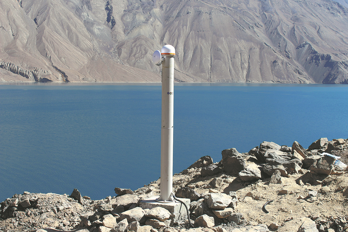
Along with providing stable navigation services worldwide, the Beidou global satellite navigation system developed by China has been monitoring the deformation of Lake Sarez in the seismically active zone of the Pamir Plateau in eastern Tajikistan for nearly three years, predicting potential earthquakes.
"Forty donkeys, 10 scientists and 30 others spent 10 days transporting the necessary equipment up to the dam at the lake. Finally, over the beautiful lake, we received signals from China's Beidou Navigation Satellite System," said Tu Rui, dean of the College of Geodesy and Geomatics at the Shandong University of Science and Technology.
The monitoring system started operating in October 2021, and since its expansion the following year, the Beidou monitoring network at Sarez has been consistently monitoring millimeter-level deformations on the dam and providing data.
"After more than two years of observation, we have noticed a certain degree of deformation in the dam. As the region has entered a dangerous period for the outbreak of a new round of major earthquakes predicted by seismologists, this real-time monitoring and analysis data are of great significance," said Tu, the project leader and a former researcher at the National Time Service Center of the Chinese Academy of Sciences.
Sarez is a natural barrier lake that was formed by a landslide after a strong earthquake in 1911. On its northwest side, the Usoi Dam, with a height of 567 meters, was also formed due to a landslide, making it the world's tallest natural dam.
Over the past century, concerns about a potential disaster at Lake Sarez have been growing among Central Asian countries. The Pamir Plateau is in a seismically active zone, and in recent years, incidents of rockfalls on the shores of the lake have occurred due to earthquakes and other factors. So far, no major disaster has occurred.
Currently, there is a 2,000-meter-long structural crack along the right bank of the lake, following the Muzkol mountain range. If the mountain collapses, it could cause flooding, rapidly devastating villages within hundreds of square kilometers, submerging crops and vegetation, according to Wang Weisheng, an expert who also participated in the project.
In 2021, the CAS Research Center of Ecology and Environment of Central Asia organized a joint effort with the CAS National Time Service Center and the CAS Xinjiang Institute of Ecology and Geography to bring domestic technology and analytical methods to Tajikistan. They used Beidou technology to monitor deformations in the Lake Sarez dam.
Tu said that in the initial stages of the project, there was no electricity, roads, or internet connectivity around the lake, and the Chinese-Tajik scientific team had to work step by step to resolve these problems.
In early April 2021, the CAS Research Center of Ecology and Environment of Central Asia organized a technical team to construct a simulation system and conduct tests at the Fukang Desert Ecosystem National Field Scientific Observation and Research Station in the Xinjiang Uygur autonomous region. They conducted tests simulating special scenarios such as prolonged power outages and the loss of communication links, repeatedly analyzing reasons for any issues and updating the software and hardware, Wang said.
"In terms of equipment, we focused on lightweight and low-energy consumption to adapt to the extreme local environment," Tu said.


- Law aimed at bolstering standard Chinese language education passed
- Connecting cities, changing lives
- World's longest expressway tunnel opens to traffic
- Taiwan lawmakers vote to pass motion to impeach Lai
- Xi: Steadfastly implement conduct rules
- Beijing community leads the way in grassroots governance